
Key Features
- Ease of Use
These algorithms and models need minimal configuring. Users can set up and run these models within minutes.
- Actionable InformationThe output derived from these algorithms and models will provide immediate actionable information.
- Up to Date Algorithms and Models Up To DateThese algorithms and models were developed to solve real world needs and will be updated to reflect the latest industry needs.
Use Cases
The following queries and algorithms, together with Quadrant’s location data, can be used to:
- Identify people who live in areas/zones/clusters that are affected by the COVID-19 virus
- Marrying medical data (such as chest X-ray results) with location data, may be able to uncover hotspots where people contract the virus more seriously (see link to article)
- Identify people who visited at specific time-frames known COVID-19 clusters
- Identify people who have been in contact with people who had previously visited high risk areas or known clusters
- Identify people who have been in contact with people who had previously visited other countries which are particularly high risk (e.g. Italy, China, USA, Iran and more).
- Derive quick statistics and numbers of people living in and visiting high risk areas or known clusters on an on-going basis.
- Based on known high risk areas or clusters, identify other potential high-risk areas that people frequently visit (cluster tracing)
Geo-fencing Query
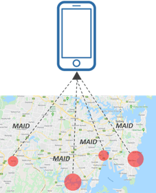
- Description: Create customized geofences around high risk zones or known COVID-19 clusters to obtain the device IDs of distinct users that fall within the specified area, that can vary in scale and shape – as small as a store or as big as a city.
- Output: List of device IDs of distinct users that fall within the specified area.
Clustering Algorithm
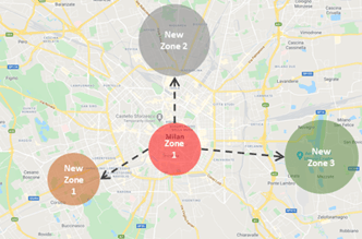
- Description: Identify areas or clusters of locations where people who are tested positively or highly exposed to the virus spend the most time
- Output: Centroid of clusters for given input coordinate data
Quadrant Circle or Polygon Geofence Footfall Query
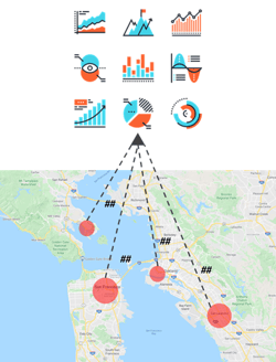
- Description: Calculate footfall within areas or clusters which have been highly affected, or that are at risk.
- Output: Total number of distinct devices which are seen within an area.