|
MOBILE LOCATION DATA RESOURCES
TECH DOCS Cross Account Bucket Access - AWS Integration Create a Database, Table and Partition How To Run Basic Location Data Queries
PUBLISHER SOLUTIONS Consent Management Knowledge Base
|

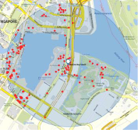
A geofence is a virtual fence around real-world locations, such as, restaurants, airports, public venues or shopping malls. This tool allows Quadrant Platform’s users to set a customized geofence to obtain the Ad-IDs of distinct users that fall within the specified area, that can vary in scale and shape – as small as a store or as big as a city.
Ad-ID is the industry standard for identifying advertising assets across all media platforms, increasing the transparency and accountability in the advertising marketplace. Quadrant Geofencing Query of Ad-IDs enables a more granular audience measurement across multiple platforms, allowing delivery of targeted messaging and creatives to the right people, at the right moment at the right place.
Types of Geo-fencing query:


Returns the daily footfall of the specified geofence. This tool can be used in multiple scenarios, from retailers looking for insights to increase the footfall to physical stores to authorities assessing traffic patterns to urban developers researching targeted areas.
Estimate the footfall of any area, region or Point Of Interest. Analyse and discover footfall patterns such as seasonality of any area, region or Point Of Interest
Uncover correlations between footfall and other variables such as store revenue. Quadrant currently offers two types of Geofence Footfall Queries:
NEAREST POI MODEL

This machine learning model identifies the nearest Point Of Interest for a given location based on the latitude and longitude values that return the daily footfall in a geofence. This model is a python-based model built using scikit learn library. It was trained using K-Nearest-Neighbours (KNN) and can also be deployed in Apache Spark framework using PySpark library.
- Analyse & understand the traveling habits of your audience
- Identify time & speed of travel from one POI to another
- Identify routes taken by an audience between two POIs
This model can be applied to existing POI data, or you can procure POI data from Quadrant as well. Learn more about our POI data offering.
We hope the information on this page equips you with the right tools to conduct a thorough data evaluation. If you are looking for a reliable location data feed or POI data contact our data consultants to get started.
Main body text.